
Around the world, transit agencies have confronted an unprecedented crisis set off by the pandemic: ridership dropped, budgets shrank, and improvements were suspended as movement came to a standstill. Despite these challenges, many agencies took this slowdown as an opportunity to take a fresh look at transit systems in terms of route efficiency, coverage, equity, and many other important factors.
Now, as commuters return to the office and ridership begins to recover, transit planners are applying these insights to future service planning. The public engagement phase, an invitation for members of the public to comment on proposed service updates, remains a vital part of the planning process — and now it’s even more critical as agencies weigh innovative new service models with a renewed focus on equity and sustainability. To help planners conduct productive and efficient public engagement processes at this key moment for public transit, here are five ways that technology can help:
1. Create accurate maps rapidly.
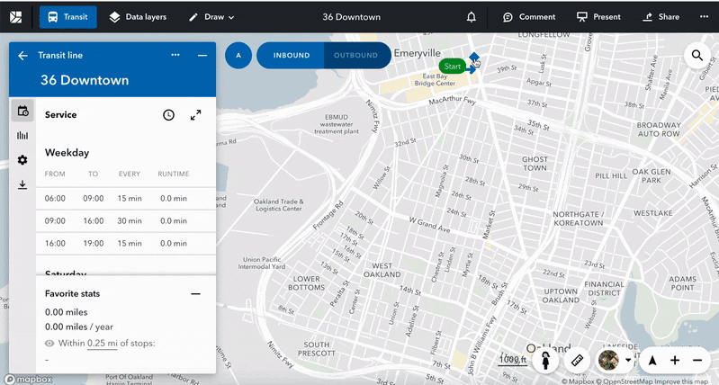
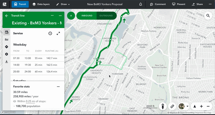
Transit planners often find it difficult to present service details to the public, especially when it comes to combining accurate maps with proposed routes and all of the relevant supporting data in a visually compelling way. Teams may be grabbing screenshots from Google Maps, editing them within PDFs, adding graphic overlays manually. Not to mention that in some agencies, all of this complicated and time-consuming work may fall to a small team or just one person.
Not surprisingly, the results may vary widely in quality, and a confusing map can quickly derail public engagement. New tools specifically designed for collaborative, iterative planning can help any team quickly create, update, and share clear and accurate maps. They allow planners to simply draw new routes on digital maps, while automatically adding stops from the current network. This capability does not require any special expertise beyond intuitive dragging and dropping, so the process is easy to manage and efficient. And the final output looks consistently professional, inspiring greater public confidence.
2. Sell the change.
One of the biggest challenges of service planning is justifying proposed route changes to the community. Without a clear comparison between the old and new routes, riders might fear disruption caused by changes to their daily routines or access to essential services. Often, the maps and supporting points become disconnected during the presentation, leaving the audience unsure of the rationale.
Collaborative planning software automatically integrates key data points into the map as it is created. For example, you can draw a new route and have it automatically add data points on frequency, cost, and demographics — all of which change instantly as you edit the route. You can also add compass directions, ridership data, other operational statistics like estimated number of buses or timetables. Both old and new route maps have the same types of data for an apples-to-apples comparison, which helps planners clearly state the case for change using accurate information and back it up with confidence.
3. Discuss trade-offs.
When asking for input from the public, it is crucial to find ways to educate community members so they can understand the context. Explaining trade-offs in transit planning is paramount: as funds are limited, agencies must prioritize the needs and goals of the public.
With new service planning technology, you can easily show your riders how one decision impacts other factors . For example, you can quickly demonstrate how changing service to arrive every 10 minutes adds to the total project cost, or how one proposed route would have more stops than another route, or why a new route would cost more but open up access to more riders. Experienced users can even do this in real-time during a presentation, adjusting the proposed route based on the audience’s suggestions.
4. Show the bigger picture.
Given the Department of Transportation’s renewed emphasis on reassessing equity in transit, agencies will need to look beyond ridership and really consider a different metric for transit usefulness: access. This not only means more complex decisions on route planning, but sharing a different type of story during public engagement.
Previously in fixed route planning, the emphasis was on the A-to-B connections of where people live and where they work. Today, there is a greater understanding of the many-to-many connections necessary to help the community — as a whole, inclusive of everyone — access essential services, such as grocery shopping, education, and healthcare. Again, new visualization platforms can help you build these route maps more efficiently as well as incorporate important data about local populations, demographics, usage levels, and access to “lifeline” services to communicate these changes effectively and convincingly.
5. Generate better feedback.
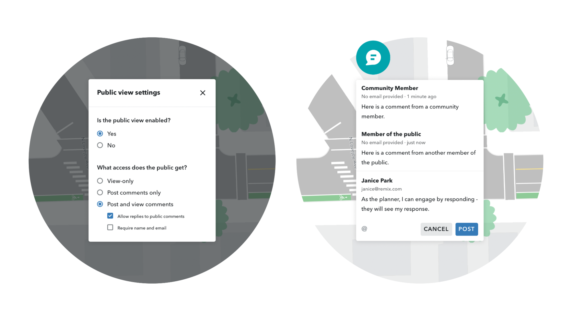
Before the pandemic, one of the most popular channels for public engagement was the in-person open house. However, these events often attract a relatively small proportion of the community — no matter how carefully the meeting time is selected.
Thankfully, technology is opening new opportunities to solicit and collect feedback. Digital maps created to explain service planning, for example, can easily be posted to a website where members of local communities can add their comments directly. Planners are notified when comments are posted and can respond to them within the software interface. Best of all, there is no need to attend a meeting in person at a specific time or place, which means a larger, more diverse group of people can share their feedback on the proposed change. Many digital platforms allow community members to post comments in languages other than English, removing another common barrier to participation. Plus, new service planning maps can be promoted on social media as well for an even wider reach.
Making public engagement easier.
Even the best ideas will falter without community buy-in, and even the most well-planned projects can benefit from suggestions that only local riders can provide. By adopting new technology, transit agencies can achieve both goals more easily during public engagement — and ultimately plan an efficient and equitable system that better serves local communities.


